


Alert
The boat ramp is open at this time.
Due to the lake being drawn down to assist with the control of Giant Salvinia, the lake will experience low water levels from time to time. Please be aware of periodic low water events and please call ahead to determine if the ramp is open.
Clean your boat trailers!
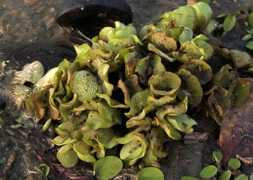
Giant Salvinia is a highly invasive floating aquatic plant that has been confirmed in Lake Tom Bailey. Please remove all vegetation from your boat trailers before leaving launch areas.
Fishing Report
Lake Tom Bailey - 4/16/2024 8:46:18 PM| Species | Detail | |
| Largemouth Bass | No new report. Bass have been biting fair. | |
| Crappie | No new report. Crappie are biting good with jigs and minnows. | |
| Bream | No new report. Bream have been biting fair on red worms. Good numbers of large redear sunfish are being caught. | |
| Catfish | No new report. Catfishing is fair with some large fish being caught on chicken liver. | |
Water temperature: 65°F Water visibility (inches): 24 muddy
Report provided by Mr. Jason Thigpen, Central Region Lakes Supervisor
Special Fishing RegulationsSpecies |
||
| Species | Type | Length To Release |
| Catfish | No length limit | |
Creel Limits (per person, per day) |
||
| Type | Amount | Additional Information |
| Catfish | 10 | Creel limit for all State Fishing and State Park Lakes |
- Only rod and reel or pole fishing is allowed on State Fishing Lakes except that carp, gar, buffalo, and bowfin may be taken by use of bow and arrow at night only after purchasing a valid permit for fishing and/or boating. No other gear is allowed at these lakes.
- Fishing is not allowed from courtesy piers adjacent to boat ramps. Night fishing is allowed from the bank or boats which are in compliance with state and coast guard regulations.
Additional Information
For information about Lake Tom Bailey, please call (601) 632-4679.
Mississippi Department of Wildlife, Fisheries, and Parks Fisheries Biologists use various sampling methods to assess the fish populations in the State’s waters. Sampling results for selected water bodies are summarized in Reel Facts Sheets
GPS Coordinates for brush piles that were added 1/12/16 are listed below.
| N 32.42285 | W 88.51477 | N 32.42555 | W 88.51812 |
| N 32.42404 | W 88.51488 | N 32.42561 | W 88.51801 |
| N 32.42430 | W 88.51518 | N 32.42553 | W 88.51788 |
| N 32.42408 | W 88.51507 | N 32.42570 | W 88.51792 |
| N 32.42408 | W 88.51528 | N 32.42561 | W 88.51780 |
| N 32.42440 | W 88.51548 | N 32.42528 | W 88.51798 |
| N 32.42427 | W 88.51527 | N 32.42521 | W 88.51812 |
| N 32.42352 | W 88.51484 | N 32.42564 | W 88.51766 |
| N 32.42377 | W 88.51519 | N 32.42551 | W 88.51769 |
| N 32.42409 | W 88.51606 | N 32.42573 | W 88.51742 |
| N 32.42399 | W 88.51614 | N 32.42510 | W 88.51762 |
| N 32.42411 | W 88.51629 | N 32.42495 | W 88.51744 |
| N 32.42420 | W 88.51608 | N 32.42518 | W 88.51726 |
| N 32.42412 | W 88.51650 | N 32.42524 | W 88.51730 |
| N 32.42398 | W 88.51634 | N 32.42522 | W 88.51714 |
| N 32.42540 | W 88.51815 | N 32.42543 | W 88.51722 |
| N 32.42547 | W 88.51802 | N 32.42524 | W 88.51759 |

