
If you have questions about purchasing a license call 1-800-5GO-HUNT.
*Arkabutla Reservoir is a flood control reservoir in north Mississippi operated by the U.S. Army Corps of Engineers (COE). The MDWFP Fisheries Bureau manages the lake's fisheries resources and provides weekly fishing reports.
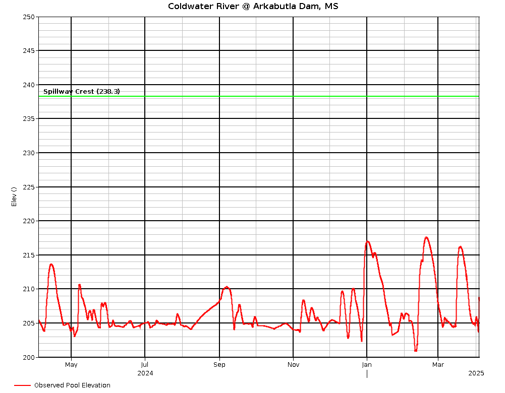
Arkabutla Reservoir is one of four flood control reservoirs (FCRs) in north Mississippi. Built by the US Army Corps of Engineers (COE) in 1943 on the Coldwater River, it is the smallest FCR with a summer pool of 11,870 ac. Water level follows an annual rule curve but deviates from it due to local precipitation and COE spillway gate operations. The reservoir is lowered in fall to winter pool (4,640 ac); flood pool is 33,400 ac. Arkabutla is a popular destination for crappie and catfish anglers. The lake is currently being maintained at a low level for dam assessment and repair. Any water level rise is followed by a fast drawdown.
For more information on this lake's fees, permits, rules and regulations, and amenities visit the Arkabutla Lake page at the U.S. Army Corps of Engineers website.
Recent heavy rainfall has raised the lake above its normal summer pool level. Expect the COE to drain it back down as soon as possible.
News on the dam assessment and repair can be found at UPDATE: Interim Repairs near completion at Arkabutla Dam
New crappie regulations went into effect on July 24, 2024 on the four Flood Control Reservoirs (Arkabutla, Sardis, Enid, and Grenada) and their spillways.
The daily creel limit for crappie is 10 fish per angler, and the daily aggregate limit is 25 fish for boats with three or more anglers. Crappie must be over 12 inches, and the pole limit remains at 4 per angler. In addition, fish may only be cleaned at designated fish cleaning stations if available, not on the water or in the boat ramp parking lots. In the spillways, the daily limit is 10 fish per angler. There are no boat or size limits in the spillways. Pole limits in the rip-rapped portions of the spillways remain 1 per angler.
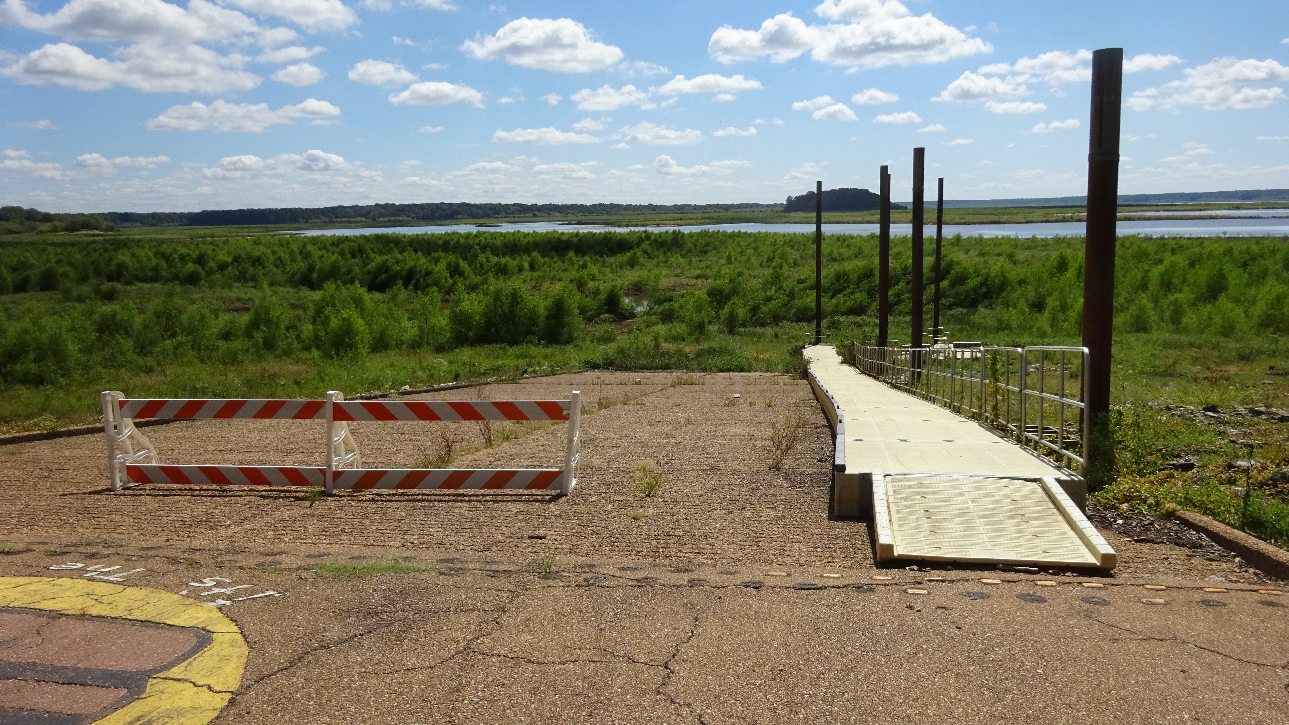
All ramps are blocked off except for the gravel one into the north river channel at Hwy 51 landing parking lot. How far you can go there is limited by river flow and/or lake level. Creek and river bank fishing are other options.
For COE regulations, see: US Army Corps of Engineers
| Fish | Flooding will allow fishing from the bank in various areas. The best luck would be for catfish as they search for worms and other invertebrates in recently flooded areas. Some crappie may move shallow, but fish will be extremely scattered in heavy cover. Fish from the bank or in creek and river pools for bass, crappie, white bass, or catfish. Most reports have been for catfish. White bass are in the river and creeks on their spawning run. Use baits and lures appropriate for your target fish (ex. soft plastics for bass, jigs for crappie, natural baits for catfish). Rain runoff usually triggers a catfish bite. |
More seasonal temperatures are in store this week with rain moving in this weekend. Water levels should not fall very fast since the COE cannot release much water with the Mississippi River flooding.
All fishing regulations remain in effect. It is a good time to take pictures or waypoints of bottom cover or habitat for when the lake refills. Be very careful around steep banks or soft bottomed areas. Some fish have survived in the main lake, sloughs, and creek and river channels.
Check water level trends; except for catfish, fishing is usually better on a slow fall than a fast rise. Be aware water rises and drawdowns will be very rapid.
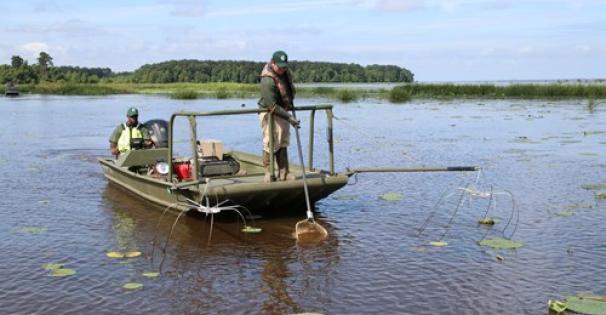
The extended drawdown is allowing vegetation to colonize exposed areas, providing habitat, cover, and food for fish, aquatic invertebrates, waterfowl, and other wildlife when re-flooded. Flooded vegetation also settles sediment out of the water. A September 2024 habitat survey found lots of 6 to 16 ft tall willows colonizing around the new waterline, lake bottom, and creek banks (Dub Patton ramp, above). Other wetland trees (cottonwood, cypress, etc.) were scarcer and smaller. Smartweed (seeds are good duck forage) was also abundant.
The spillway area is closed to fishing because of the dam repair.
The spillway had two gates open 1.5 ft, one gate open 19.0 ft (4165 cfs) Tuesday. The COE will increase outflow as soon as possible to bring the lake back down. Spillway gate openings, flow rates, and spillway water elevations can be obtained at Vicksburg District Corps of Engineers OR Yazoo River Basin Reservoirs click on 24-hour change for picture explanation of gate flow, spillway flow, etc.).
All fish captured and kept with dip or landing nets, cast nets, boat mounted scoops, wire baskets, minnow seines, and minnow traps in the spillway areas bordered by rip rap must be immediately placed on ice or in a dry container. Game fish caught with these gears must be released. This regulation was enacted to reduce the potential of transferring harmful Asian carps to the reservoir or other waters.
The 12-inch crappie length limit does not apply to the reservoir spillway, but the spillway has a 10-crappie creel limit.
Water level 225.96 ft, falling 0.5 ft/day Tuesday. Expect the water level to be drawn back down as fast as possible. Ignore the rule curve as the COE maintains low water (about 205 ft) to assess and repair the dam. It may be drawn lower if rain is expected. Expect very rapid rises and drawdowns as rain events happen and the Corps tries to maintain that level. Emergency spillway level is 238.3. For water level information, call (662)562-6261 or check at Vicksburg District Daily Bulletin for a table OR Coldwater River @ Arkabutla Dam, MS for a graph OR Yazoo River Basin Reservoirs for both (click on 24-hour change for picture explanation of gate flow, spillway flow, etc.). Be sure to check the date on the table; it is usually updated midday.
| Species | Lengths to Release | Daily Creel Limits |
|---|---|---|
| Crappie (combined black and white) | 12 inches and under | 10 per angler 25 per boat for boats with 3 or more anglers |
Statewide creel and size limits apply to all other fish species
Find and learn more about *Arkabutla Reservoir...